Topographic Maps Illustrated
These two lots are in the same subdivision. They are nearly identical in size but the topography is as different as night and day!
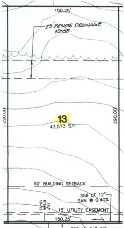
Lot number 13 is actually the best lot. Note how the topographic lines are spaced far apart. If the lot was absolutely flat from front to back and left to right, there would be no topographic lines on the plot plan. The highest point on the lot is actually at the front left corner which is the lower left corner of the illustration above. The contour intervals or lines on this plot plan are at two foot intervals. So this seemingly flat lot actually falls 20 feet across the 290 foot lot depth! Lot 27 is a nightmare lot. Why? Because of several reasons. First, it falls 20 feet in elevation from front to back in just the first 140 feet of lot depth!
Second, there is a storm water retention basin in the rear of the lot. That is what those dashed lines indicate. The developer will shape the land so a dry pond is formed at this location. When it rains heavily, storm water will fill the pond and then be slowly released as the storm passes by. These types of retention basins can accumulate herbicides and insecticides from neighboring lots! Your children can be at harm when they fill with storm water. They are a huge liability in my opinion.
Lot number 49 is a pan handle lot to begin with. Note the little tail of land in the lower right corner. This is where this lot connects to a public roadway. All of the utilities feeding this lot need to come up here and share space with the driveway. Look at the left side of the lot. See the tightly spaced contour lines that are V shaped? These indicate a creek or dry stream bed.
 |
| Here are two lots that have real topographic problems and will be tough building sites. Whats more, without seeing the rest of the plot plan you should be able to intuitively figure out that there is high ground above each of these lots that will throw surface water down on top of them. You can easily see that you will not be playing touch football games with your kids on these lots. No way, no how! |
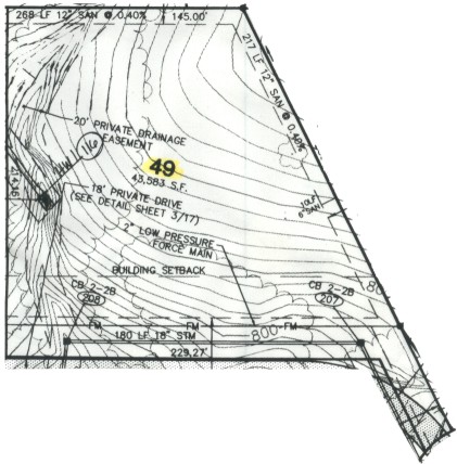 Lot 49 |
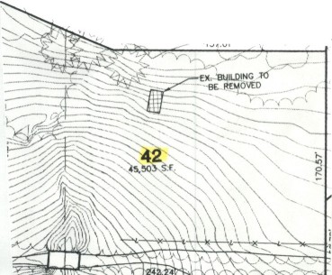
| Lot 42 is a very steep piece of land. Once again the contour interval is 2 feet. There is close to 70 feet of fall from the top of this lot to the bottom. That is an enormous amount of fall. Building on this lot will cost lots of extra money and you will need mountain climbing gear to cut your grass! Avoid lots like this one. |
 |
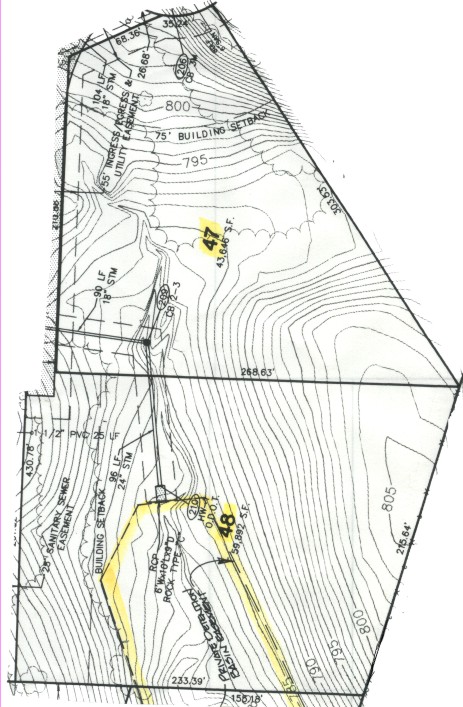
| Lots 47 and 48 are interesting. If you rotate this page, you will note that there is a creek or stream bed that starts in the upper portion of lot 47 near the words "55' INGRESS / EGRESS UTILITY EASEMENT. See how the contour lines are V shaped there? If you draw a line between the points of each contour line where it creates the "V", you will be drawing the center line of the creek or stream bed.
Lot 47 actually has a valley in it! Just below the number 47 is a small valley. As you go towards lot 48 the land rises and as you go towards the right side of lot 47 the land also rises. You can clearly see this by reading the values of the contour lines as they are printed. See the numbers 800 and 795? Those represent the height above sea level. Do you see the outline for the storm water retention basin that will be formed on lot 48? It is smack dab in the center of the lot! Who would want that? This is why you absolutely must look at topographic maps like this when you go to purchase lots. You need to see what the land is doing and what the planned drainage features are. Drainage issues are critical and they can cost you huge dollars after you move in. It takes some detective work and some thought to figure out what will happen after you move in. Study the land and look at existing subdivisions to see how land forms and shapes affect drainage. |
 |
Column B289
Tim built custom homes and did ultra-custom remodeling for 20+ years before launching his Ask the Builder media presence. He was selected as one of the Big 50 by Remodeling magazine in 1993. This award gave birth to Ask the Builder in October 1993. Tim also operates https://DrawPlumbingPlans.com. His @askthebuilder YouTube channel was the first home improvement channel on YouTube.